Category:1 & 2 Holland Place, Liverpool
Jump to navigation
Jump to search
| Object location | | View all coordinates using: OpenStreetMap |
|---|
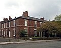
Pair of 1830s houses on Towerlands Street, part of a Grade II listed group with 2 & 2A Church Mount.
Media in category "1 & 2 Holland Place, Liverpool"
The following 2 files are in this category, out of 2 total.
-
 1 & 2 Holland Place-1.jpg 4,840 × 3,328; 8.58 MB
-
 1 & 2 Holland Place-2.jpg 4,392 × 3,440; 6.58 MB

